:max_bytes(150000):strip_icc():format(webp)/asia_minor_1849-5b13fc57eb97de00369ce9e1.jpg)
:max_bytes(150000):strip_icc():format(webp)/left_rail_image_geography-58a22da068a0972917bfb5b4.png)
Maps of the ancient Near East that can be used for personal research, for classroom or lecture use, or for publication on your website can be found on the Internet, it just takes a little digging. The websites listed below are portals for what are in some cases decades of research by dedicated scholars, some based in universities, some independent scholars. You'll find an index and a few examples of the maps available on each website listed here.
Note that terms of use are also listed in the descriptions for each site, but also know that these can change with little notice, so if you plan to use the maps on a website, be sure to contact the editors first to make sure you won't be in copyright violation.
The University of Texas at Austin: Perry-Castañeda Library
The Perry-Castañeda Library is based at the University of Texas at Austin, and truly the best of the bunch. UTA's PCL Map collections include high-resolution scans of historical atlases from all over the world.
Terms of Usage: Most of the maps are in the public domain, and no permissions are needed to copy them, no matter where you are using them. They would appreciate credit (and a small donation) to "University of Texas Libraries" as the source of the scanned images.
- PCL Map collections Index
- Maps of the Middle East
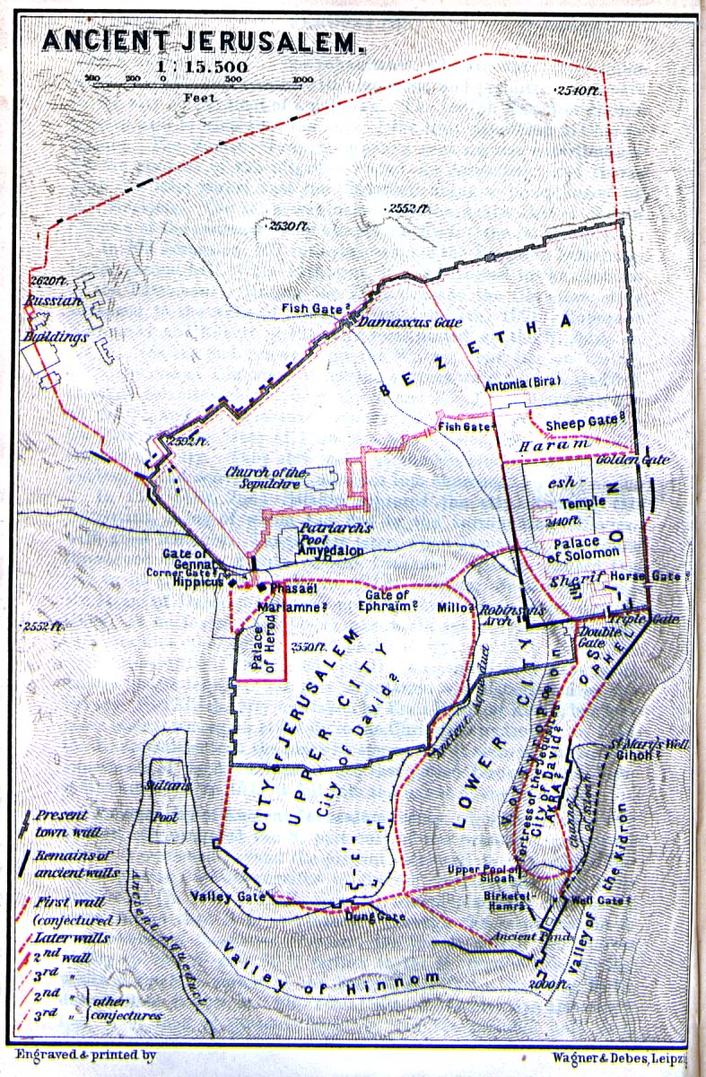
- Ancient Jerusalem, 356K JPG city map, scanned from Palestine and Syria. Handbook for Travellers by Karl Baedeker, 5th Edition, 1912, showing elevations, landmarks, modern and ancient walls.
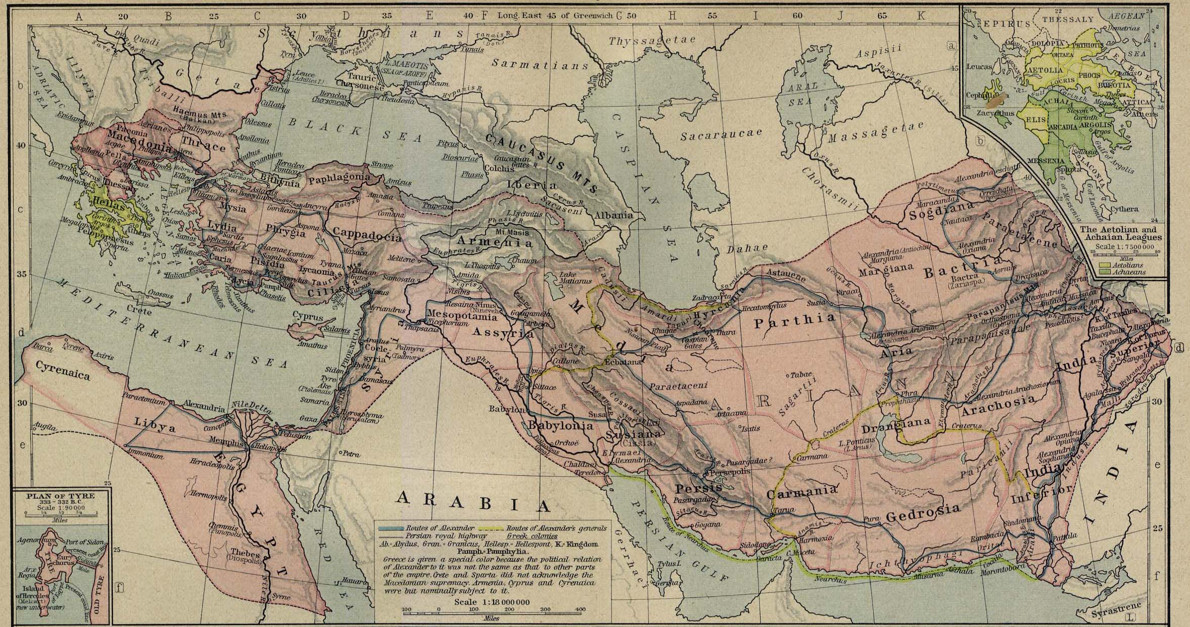
- The Macedonian Empire, 326-323 BCE, from the Historical Atlas by William R. Shepherd, 1923. Insets: The Aetolian and Achaian Leagues. Includes a plan of Tyre.
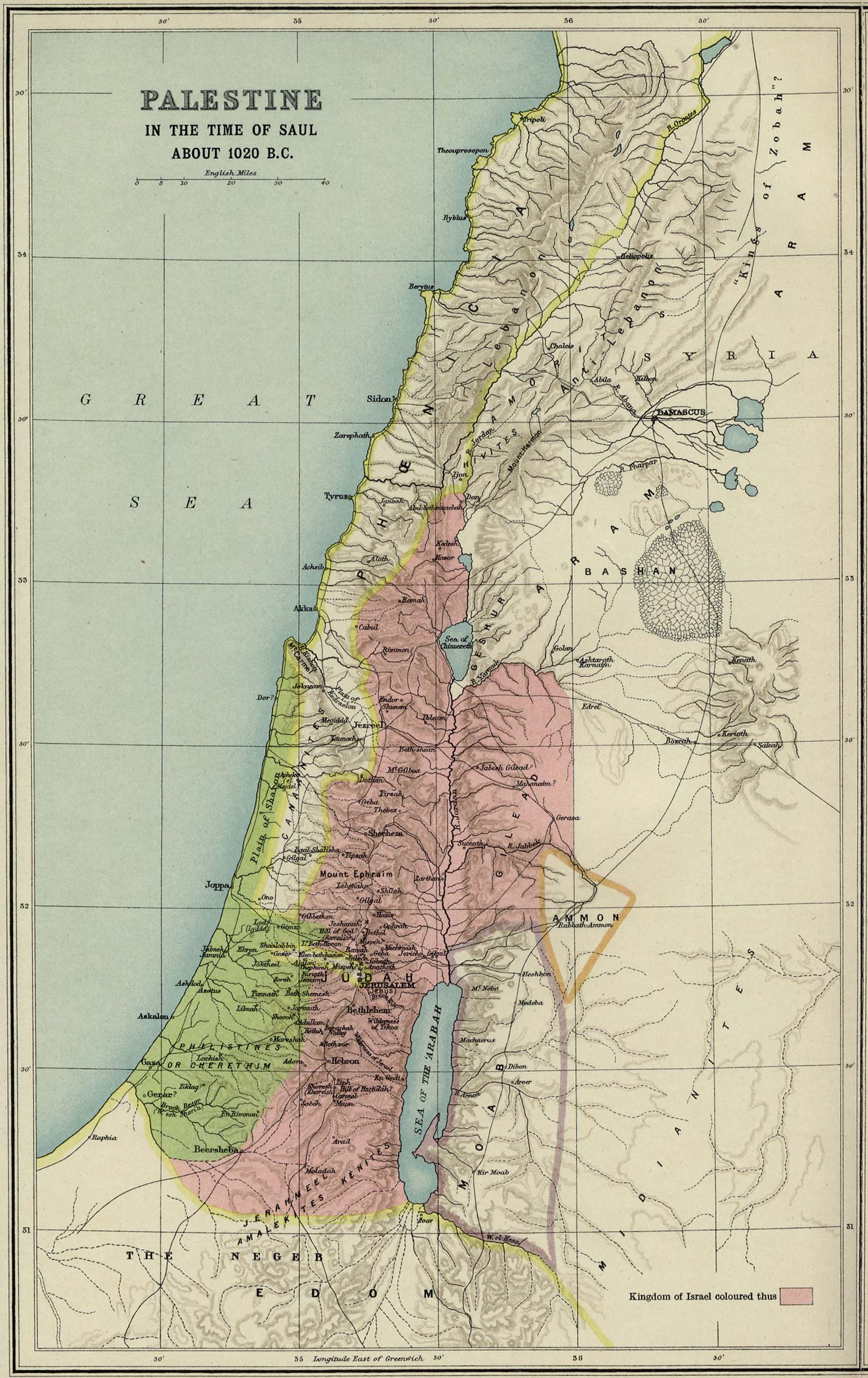
- Palestine in the Time of Saul about 1020 BCE, scanned from the From Atlas of the Historical Geography of the Holy Land. Smith, George Adam. London, 1915
David Rumsey Map Collection
David Rumsey has collected over 85,000 geo-referenced maps over the past thirty and more years, focused on very high-resolution scans of rare 16th- through 21st-century maps of the world. They are astonishing in their detail and resolution. Middle Eastern maps are in the Asia collection, with a specialized Luna viewer to assist in the creation of slideshows suitable for classroom use.
Terms of Usage: Images may be reproduced or transmitted under a Creative Commons license that allows education and personal use, but not commercial use. For commercial use, contact the editors.
- Main Index page
- Atlas index
- Luna Viewer of Asian maps
- Claudius Ptolemy's Map of the eastern Mediterranean and the Middle East from Cyrpus to Babylonia, published in 1561 by Girolamo Rscelli and M. Giuseppe Moletti
- Henry Schenk Tanner's 1819 map of the world
- Historical maps from Google Earth, some georeferenced maps are also made available by the David Rumsey Map Collection
- Geo-referenced Buddhist map of the world made in 1710
The Mapping History Project
The Mapping History Project at the University of Oregon has developed a set of interactive and animated maps of fundamental history problems that require Shockwave, as well as straight downloadable images. English and German versions.
Usage Terms: Contact the editors for academic and commercial use.
- Main Index of the Mapping History Project
- Europe Map Archive (including Ancient Near East, as well as Greek and Roman maps)
- Europe Image Library. John Nichols photographs of Roman and Greek ruins
- Political Change in Mesopotamia 3000-1000 BCE Interactive map using shockwave to show successive political waves from Sumerian to Kassite with Babylonian, Assyrian, and Agade along the way.
- Sea People of the Late Bronze Age. Map of the Near East shows major cities all located along waterways, from Troy in the north to Nile Delta cities and Memphis in the south. Also shows movements of armies and naval forces.
- Ancient Near East Empires 700–300 BCE, Shockwave interactive map.
Oriental Institute: Center for Middle Eastern Studies (CMES)
The OI'sCenter for Middle Eastern Studies (CMES) has made pdf versions of maps of the Islamic World available on its website.
Terms of Use: The terms are not specifically identified with regard to the maps, but there is a contact page that you should use before publishing these maps elsewhere.
Oriental Institute: CAMEL
The Center for Ancient Middle Eastern Landscapes (CAMEL) project at the University of Chicago's Oriental Institute has a vast collection of maps and other images from the Near East, but only a handful of the maps are currently online.
Terms of Use: Publication, distribution, exhibition, or reproduction is prohibited without prior written permission.
- Main Index for CAMEL
- CAMEL Maps, a list of available sources of public domain holdings, but you'll need to contact the OI to obtain copies.
- Search engine for OI collections. Use this to search CAMEL for maps or other resources.
- Survey of Egypt: Orographical Map of the Nile Basin
- Survey of Egypt: Map of Cairo Showing Islamic Monuments
- Ancient Near East Site Maps Index
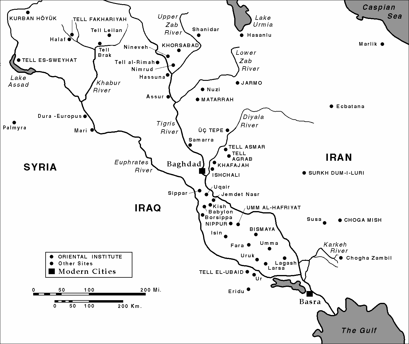
- Iraq Site Map. A greyscale map of archaeological sites in Iraq, including Akkad, Babylonia, Assyria, and Sumer located alongside the Tigris and Euphrates Rivers. Major cities and other rivers included in line drawing.
My Old Maps
Independent scholar Jim Siebold has been collecting and scanning old maps and writing detailed monographs about them since the turn of the 21st century, under a range of different websites beginning with the Henry Davis Consulting Firm. His most current and up-to-date version of the ongoing project is the My Old Maps website.
Terms of Use: Low-resolution images may be downloaded and used with accreditations; high-resolution images are available for free from Siebold on request.
- My Old Maps Main index
- Maps from Antiquity index
- Babylonian Clay Tablet World Map. Circular map from 600 BCE which if the interpretive redrawing is correct shows Babylon, Armenia, and the Bitter River.
- The Earliest Known Map, town plan of 6200 BCE Catal Hoyuk.
HyperHistory Online
HyperHistory Online is a long-term project by architect and independent scholar Andreas Nothiger, whose main claim to fame is a huge History Chart that begins with the Old Testament prophets of David and Solomon and ends with World War II. He has a substantial collection of maps, drawn for his project.
Terms of Use: Not listed on the website, but an email contact is provided.
- Main Map Index for HyperHistory Online
- Index of Maps of Antiquity
- Sumer
- Israel and Judah.
Bible Maps
Bible Maps is a Canadian website that has loads of maps, constructed on the basis that the Bible is literal fact, pure and simple; chronologies are based on strict biblical interpretations.
Terms of Use: Free to look at, print, and share in churches and schools, but not permitted to sell or post on line. Details on use and construction are listed on the home page.
- Main Index
- Twelve Tribes, as described in the book of Joshua
- Abraham's Journey from Ur
Al Mishraq: The Levant
Al Mishraq is a Norwegian site dedicated to the history and archaeology of the Levant region of western Asia. The site has a handful of interesting maps, but they are spotty in quality.
Terms of Use: Not provided on the site, but an email address is provided on the homepage.
- Index of Maps and Geography
- 15th Century Map of the Arabic World, high-resolution image of Nazam al-Din al-Hussein bin Muhammad al-Nishapuri's Sharh al-Tadhkarah map.
- Map of Beirut, 1876, from the Danish Vice-Counsel Julius Löytved
- A Glimpse of Yesterday. In addition to showing the place name variations between Aramaic, Canaanite, and Arabic, the site explains the arbitrary temporal and geographic distinctions between Ancient Near East and Middle East.
:max_bytes(150000):strip_icc():format(webp)/old-maps-online-screenshot-58b9d13d3df78c353c38c289.png)
:max_bytes(150000):strip_icc():format(webp)/GettyImages-200399001-001-58b9cbdb5f9b58af5ca72f89.jpg)
:max_bytes(150000):strip_icc():format(webp)/globe-5b43535d46e0fb00370212cc.jpg)
:max_bytes(150000):strip_icc():format(webp)/GeographyMap-GettyImages-112303536-57a492845f9b58974a1f5292.jpg)
:max_bytes(150000):strip_icc():format(webp)/friends-reading-map-in-woods-france-91797230-589c98e45f9b58819c07fa1d.jpg)
:max_bytes(150000):strip_icc():format(webp)/GettyImages-200218047-001-5acb08473de4230036857f79.jpg)
:max_bytes(150000):strip_icc():format(webp)/ind044-58b9d2443df78c353c392151.jpg)
:max_bytes(150000):strip_icc():format(webp)/presidential-election-usa-map-518000720-58b9d2575f9b58af5ca8b3bb.jpg)
:max_bytes(150000):strip_icc():format(webp)/map-58b9d2665f9b58af5ca8b718-5b859fcc46e0fb0050f10865.jpg)
:max_bytes(150000):strip_icc():format(webp)/getty-historic-map-works-brooklyn-58b9d1ad5f9b58af5ca86b6a.jpg)
:max_bytes(150000):strip_icc():format(webp)/map-56a3651c3df78cf7727d1f69.jpg)
:max_bytes(150000):strip_icc():format(webp)/topomap2-56a364da5f9b58b7d0d1b406.jpg)
:max_bytes(150000):strip_icc():format(webp)/national-hurricane-center-595154358-5adf3a9e8e1b6e0037ede49b.jpg)
:max_bytes(150000):strip_icc():format(webp)/phaidon20-bag-56a02b693df78cafdaa0650a.jpg)
:max_bytes(150000):strip_icc():format(webp)/GettyImages-79251182-5b7345e446e0fb0050b69d2c.jpg)
:max_bytes(150000):strip_icc():format(webp)/RobisonProjection-5b8cb82846e0fb002519539c.jpg)